
- Reaction score
- 1,677
A new stratospheric Polar Vortex has now emerged over the North Pole and will continue to strengthen well into the Winter of 2021/2022. It will interact with a strong easterly wind anomaly high over the tropics. This interaction happens every few years and has actually brought colder winters to Europe and the United States in the past.
Before explaining what is coming for the Polar Vortex and our Winter weather, we will quickly learn what exactly is the Polar Vortex. We try to explain this in most of our winter articles, as knowledge is essential and powerful, so why not learn something new very quickly along the way.
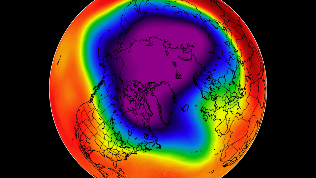
In essence, the polar vortex is like a large cyclone, that forms when the stratosphere over the North Pole starts to cool down. The image below shows an example of the pressure pattern in the lower stratosphere, with the Polar Vortex covering the Polar Regions and down into the mid-latitudes. But what exactly is this “stratosphere”?
All of the clouds (and the weather that we feel) are found in the lowest layer of the atmosphere called the troposphere. It reaches up to around 8 km (5 miles) altitude over the polar regions and up to around 14-16 km (9-10 miles) over the tropics.
Above it, there is a much deeper layer called the stratosphere. It is a very dry layer, around 30km thick. This is where the ozone layer is. You can see the layers of the atmosphere on the image below, with the troposphere on the bottom and the Stratosphere with the ozone layer above it.
When you hear people talk about the polar vortex and its influence, 90% of the time they talk about the higher altitude stratospheric part. While the stratospheric polar vortex is spinning high above our weather (tho strongly connected), it plays a major role in the developing winter weather patterns across the entire Northern Hemisphere. Every year as we head into autumn, the north pole starts to cool down. But the atmosphere further south is still relatively warm as it continues to receive energy from the Sun. This temperature difference causes a pressure drop over the polar regions.
 www.severe-weather.eu
Before explaining what is coming for the Polar Vortex and our Winter weather, we will quickly learn what exactly is the Polar Vortex. We try to explain this in most of our winter articles, as knowledge is essential and powerful, so why not learn something new very quickly along the way.
In essence, the polar vortex is like a large cyclone, that forms when the stratosphere over the North Pole starts to cool down. The image below shows an example of the pressure pattern in the lower stratosphere, with the Polar Vortex covering the Polar Regions and down into the mid-latitudes. But what exactly is this “stratosphere”?
All of the clouds (and the weather that we feel) are found in the lowest layer of the atmosphere called the troposphere. It reaches up to around 8 km (5 miles) altitude over the polar regions and up to around 14-16 km (9-10 miles) over the tropics.
Above it, there is a much deeper layer called the stratosphere. It is a very dry layer, around 30km thick. This is where the ozone layer is. You can see the layers of the atmosphere on the image below, with the troposphere on the bottom and the Stratosphere with the ozone layer above it.
When you hear people talk about the polar vortex and its influence, 90% of the time they talk about the higher altitude stratospheric part. While the stratospheric polar vortex is spinning high above our weather (tho strongly connected), it plays a major role in the developing winter weather patterns across the entire Northern Hemisphere. Every year as we head into autumn, the north pole starts to cool down. But the atmosphere further south is still relatively warm as it continues to receive energy from the Sun. This temperature difference causes a pressure drop over the polar regions.
Stratospheric Polar Vortex returns for Winter 2021/2022, together with a strong easterly wind anomaly high above the Equator, impacting the Winter season
Polar Vortex returns for Winter 2021/2022, together with a strong easterly wind anomaly high above the Equator, impacting the Winter season
www.severe-weather.eu
/u/_tropical_tundra_ said:Here’s the TLDR:
So store up on hot cocoa. (I may have added that, read the article to figure out if I did.)
- The polar vortex is forming - as it does every year
- The tropical equatorial winds are moving east until the end of the year
- A warming event is expected to pull even more cold air down
- The US, central and Northern Europe will be freezing their asses off.

